
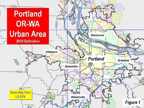
Among urban planners, there is probably not a more revered urban area in the world than Portland (Oregon). The Portland metropolitan area and its core urban area , principally located in Oregon, stretches across the Columbia River into the state of Washington (Figure 1). Nearly four decades ago, the state of Oregon adopted strong urban planning requirements, including the requirement of an urban growth boundary. Two principal purposes of the resulting policies (referred to as “smart growth,” “urban containment, “compact cities,” etc.) were densification and transferring travel demand from cars to transit.
Portland’s progress toward these objectives has been modest, at best. Most growth has continued to be in the suburbs. There has been only modest densification, and employment has continued to disperse from the core. At the metropolitan area level, travel by car remains virtually as dominant as before and traffic congestion has intensified materially. Finally, house prices have been driven up relative to incomes (Note 1).
Portland: A Dispersing Metropolitan Area
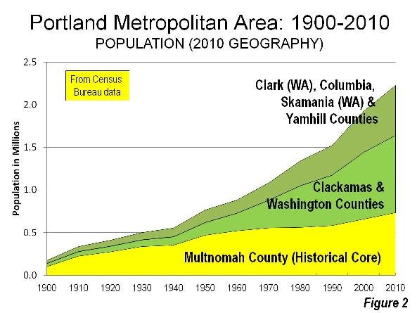
Like virtually all major metropolitan areas in the world, Portland has experienced substantial dispersion. The core county of Multnomah peaked at more than two thirds of the metropolitan area population in 1930, as defined in 2000 (Note 2). By 2010, Multnomah County had dropped to one third of the metropolitan area population (Figure 2).
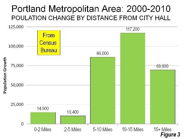
The dispersion has continued in recent years, though there has been core growth (as has been the case in many metropolitan areas). Between 2000 and 2010, the area within two miles (three kilometers) of Portland City Hall grew more than 20 percent. However, this was only five percent of the metropolitan area’s growth. In the inner ring extending to five miles (eight kilometers) from City Hall, the growth was only three percent, well below the metropolitan area’s overall 15 percent growth rate. More than 90 percent of the metropolitan area’s population growth was outside a five mile radius (Figure 3).
Portland: A Low Density Urban Area
Despite its international reputation as an exemplar of compactness , Portland is a low density urban area. Among the 875 urban areas in the world with more than 500,000 population, 797 are denser than Portland.
In the low density United States, Portland ranked 12th among major urban areas (over 1 million population), at approximately 3,500 residents per square mile (1,350 per square kilometer) in 2010. This is approximately 10% higher than the major urban area average density but barely half that of the densest, Los Angeles, with its undeserved reputation for low-density, “sprawling” development (Figures 4 and 5).
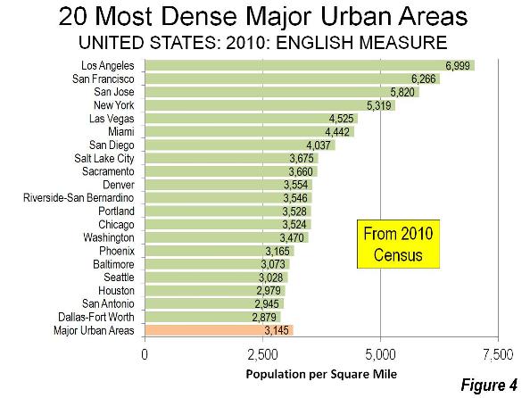
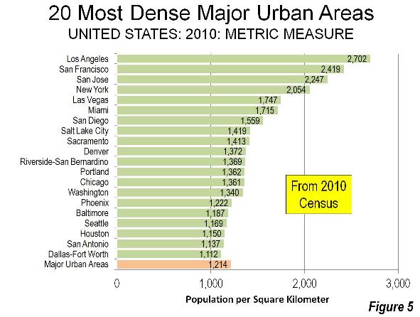
Portland is less dense than all major urban areas in the 13 western states, with the exception of Seattle. Notably, Riverside San Bernardino is denser, despite consisting almost exclusively of post-World War II automobile-oriented development. Even much smaller California urban areas, such as Stockton, Bakersfield, Lodi and Delano are denser than Portland.
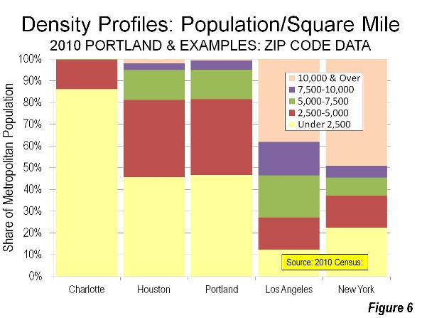
Portland and Houston: Density Cousins
The Portland metropolitan area’s density profile nearly duplicates that of Houston, which is just as famous for its liberal land use and transportation policies nearly the opposite of Portland’s (Note 3). Both metropolitan areas have nearly the same percentage of their populations living at densities below 7,500 per square mile (2,865 per square kilometer). A 40 percent larger share lives at densities of from 7,500 to 10,000 per square mile (3,860 per square kilometer) in Portland, while Houston’s share of its population living at densities above 10,000 per square mile is three times that of Portland (Figure 6).
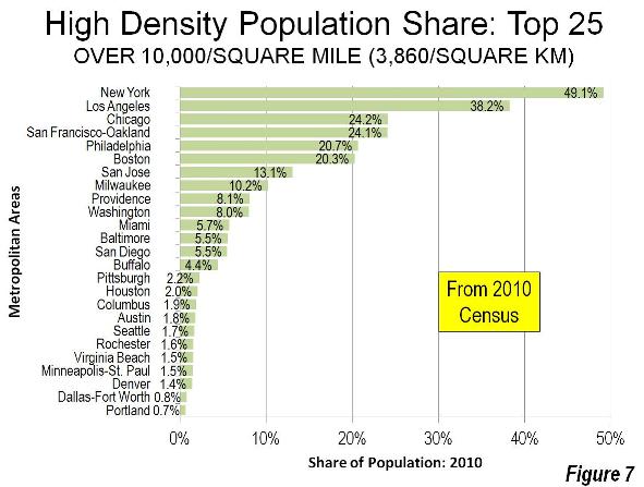
Among the nation's 51 major metropolitan areas, Portland ranks 25th in the share of population living in zip codes with more than 10,000 people per square mile in 2010 (Figure 7).
Portland’s Job Dispersion
As in other metropolitan areas, jobs have dispersed substantially around Portland. Today, fewer than 10% of the jobs are located in downtown Portland (the central business district). The city of Portland itself has approximately 1.41 jobs per resident worker. Suburban Hillsboro, with the third largest employment base in the metropolitan area, has slightly more jobs per resident workers (a higher “jobs-housing balance”) according to American Community Survey data.
Transit in Portland
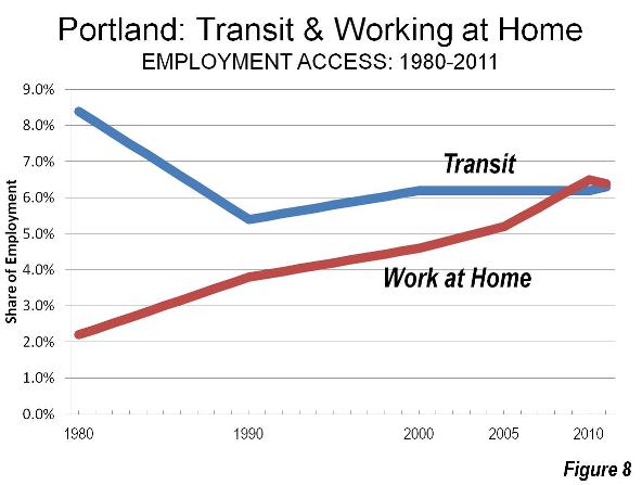
Portland has developed an extensive rail system, intended to attract drivers from their cars. Today, six light rail lines (five light rail) radiate toward the urban periphery, focusing on downtown (the central business district, or CBD).
Yet the share of commuters using transit has fallen by a quarter since 1980, the last data available before the first light rail line opened. In short, rail has not changed the calculus of travel in Portland. Working at home, which is a less expensive and more environmentally friendly work access mode, has caught up with and now exceeds transit, as has occurred in most US major metropolitan areas. (Figure 8)
Worse, transit may have already experienced its “best of times.” The future could be grim. Opposition to rail expansion has grown, and longer term transit service cuts of up to 70 percent have been threatened. (See Portland’s Transit Halcyon Days?)
As elsewhere, transit in Portland is “about downtown.” The Portland Business Alliance estimates that 36% of downtown workers commute by transit. This is nearly one-half of all transit commuting in the Portland metropolitan area. Even in the job rich suburbs of Hillsboro and Beaverton, the share of people using transit for the work trip is less than the 5.0 percent national average.
Portland: Intensifying Traffic Congestion
Clinging to the fantasy transit can materially reduce automobile travel, Oregon officials have blocked substantial roadway expansions. Residents have been rewarded with much intensified traffic congestion.
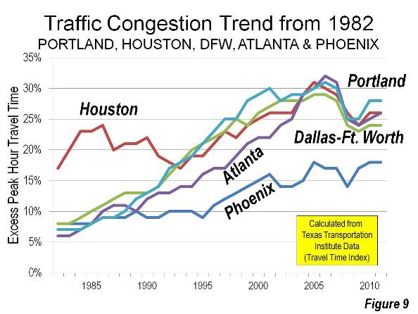
The Texas A&M Texas Transportation Institute Annual Mobility Report (Note 4) reveals Portland to have the 6th worst traffic congestion in the nation among major metropolitan areas. This compares to a before-rail ranking of 39th in 1982. Now Houston, Atlanta, Dallas-Fort Worth and Phoenix all have lower levels of traffic congestion than Portland (Figure 9). Without decades of urban containment and anti-mobility policies, these metropolitan areas have improved traffic congestion relative to Portland. This is despite far larger increases in travel demand. Since the early 1980s, each of these metropolitan areas has added more residents than live in the entire Portland metropolitan area. Portland also ranks among the worst (5th) in commuter stress (a measure of peak direction traffic congestion), according to the Annual Mobility Report
Portland: Congestion and Higher Greenhouse Gas Emissions
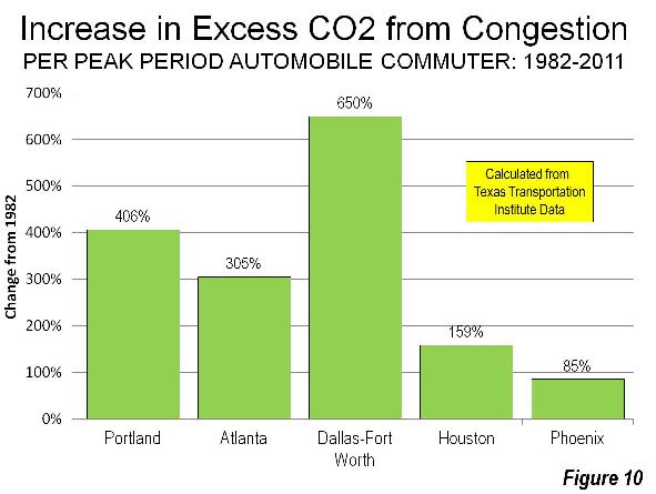
Reflecting the reality that greater traffic congestion increases greenhouse gas emissions, Portland’s carbon dioxide (CO2) emissions per automobile commuter have increased substantially and transit has made only the scantest difference. Between 1982 and 2011, Portland’s increase in CO2 emissions was greater than Houston, Atlanta and Phoenix, though less than Dallas- Fort Worth (Figure 10).
Deteriorating Housing Affordability in Portland
In Portland, consistent with both economic principle and considerable research, urban containment policy drives house prices up relative to incomes higher by rationing the supply of land and housing. In 2010, values of comparable land on either side of the urban growth boundary varied by more than 10 times in value per acre (a phenomenon also identified in Auckland, New Zealand by Chairman of the Reserve Bank of New Zealand, Arthur Grimes).
The most recent Demographia International Housing Affordability Survey indicated that Portland's median multiple (median house price divided by median household income) was 4.3. In normally functioning housing markets, the median multiple is typically 3.0 or less, a ratio last achieved in Portland in 1995. This higher median house price means than approximately 125,000 fewer Portland households ---or 15% of households --- are able to afford the median priced house. (Note 5).
Higher housing costs retard the standard of living by reducing discretionary incomes (gross income minus taxes and necessities). This, in turn, leads to less demand for other goods and services (in the “discretionary economy”), less job creation and less economic growth.
Even so, Portland’s rising house prices have been moderated by the nearby availability of less expensive houses on larger lots in the Vancouver area (Clark County, Washington). There, more liberal land use regulation permits consumer-driven housing choice, rather forcing households to choose from the limited offerings planning authorities prefer.
In part due to rising prices, Portland is becoming less diverse . Indeed, Aaron Renn has called Portland the penultimate example in his searing critique, The White City. After the results of the 2010 census were announced. The Oregonian quoted then Mayor Sam Adams’ concern about the exodus of African-Americans from the city (municipality), saying that Portlanders should care about the fact that we offer ¬such limited access to equal opportunities. Local policymakers are largely oblivious to the role that urban containment policy may have played in diminishing those opportunities.
Misplaced Priorities
Despite all of this, Portland has its advantages.
As in Houston, Seattle, Atlanta and virtually all other major metropolitan areas regardless of land use regulations, a core renaissance is underway that is making a dense urban lifestyle more practical for the relatively few who both prefer it and can afford it. The suburban lifestyle, dominant virtually everywhere in the United States, remains alive and well in Portland (Note 6). Portland’s physical location remains the envy of most metropolitan areas. There is little better scenery than the nearby Columbia Gorge or majestic Mt. Hood, which crowns the area on clear days.
However, Portland has been sidetracked by a pre-occupation with urban design, at least partially driven by concerns about reducing greenhouse gas emissions. The good news is that technological advances are poised to do far more to reduce greenhouse gas emissions than could ever be achieved by urban containment policy.
But scenery aside, cities are primarily economic organisms. Cities have grown by serving the aspirations of people for a better standard of living. The very purpose of cities is to facilitate affluence and minimize poverty among residents (see Toward More Prosperous Cities). Yet policies, such as urban containment, that inherently reduce household discretionary incomes and impose greater congestion costs reduce discretionary incomes. Despite intentions to the contrary, the results show this to be the real Portland story.
-----------------------------------------
Note 1: Some other metropolitan areas that have embraced urban containment policy have produced even worse results. For example, traffic congestion is worse in Vancouver, Sydney, Melbourne and far smaller Auckland, according to the “Tom Tom Congestion Index,” a real-time traffic reporting competitor to INRIX. Portland has seriously unaffordable housing, though has not retarded the standard of living nearly so much as in Vancouver, Sydney, Melbourne or Auckland, where housing is severely unaffordable. Attention is drawn to Portland’s negative outcomes because of the extent to which its policies are revered in the urban planning community around the world.
Note 2: Multnomah County is used in this analysis, instead of the historical core city of Portland, which has grown in large measure by annexation. Since 1950, the city added 108 percent to its land area and little more than half (56 percent) to its population.
Note 3: Houston is sometimes referred to as having deregulated land use. This is not strictly correct, though Houston is closer to a deregulated model than any other US metropolitan area. The city of Houston does not have zoning, though some municipalities in the suburbs are zoned. Many neighborhoods in the city of Houston have private land use covenants.
Note 4: The Annual Mobility Report has been the authoritative measure of traffic congestion in US urban areas for three decades. More recently, the report’s traffic congestion measures have been significantly strengthened by the use of actual global positioning data from INRIX, which also produces its own Traffic Scorecard both for US and international urban areas, using satellite based real-time traffic data.
Note 5: Estimated from income qualifying income requirements as reported by the National Association of Realtors for the third quarter of 2012 and the metropolitan income distribution modeled based on the 2011 American Community Survey.
Note 6: In 1999, new urbanist architect Andres Duany evaluated Portland in a commentary for The Oregonian: "To my surprise, as soon as I left the prewar urbanism (to which my previous visits had been confined), I found all the new areas on the way to the urban boundary were chock full of the usual sprawl one finds in any U.S. city, no better than in Miami. The outcome wasn't that different after all."
-------------------------
Wendell Cox is a Visiting Professor, Conservatoire National des Arts et Metiers, Paris and the author of “War on the Dream: How Anti-Sprawl Policy Threatens the Quality of Life.
Photo: Mount Hood (by author)


Lies, Damn Lies and Statistics
Interesting take on the city in which I currently reside. Reading this article gives me the distinct impression that you can no more know a city by it's statistics than you can know a person though knowing his height, age and weight. The statistics might be true, but it misses the essence of the person.
Take for instance the urban growth boundary. I don't argue the statistics presented here, but I will state that it is missing the point. Yes, there is has been more growth in Clackamas county and Washington county, but that is to be expected and it was by design when creating the boundary as they set aside wide swaths of undeveloped land waiting to be developed. Now, that area has been developed. Our density would have been higher had we made a tighter urban growth boundary, but nobody's asking for that here. I don't think many Portlanders are upset that we are less dense than the cities listed.
We are not as dense as New York city, I don't think we want to be. We just don't want continuous suburban sprawl. In this regard, your analysis is definitively missing some statistics. You should research what our population density is within the boundary, vs, outside of it. When looking at those numbers, it becomes difficult to definitively argue that we are less dense than what we otherwise would have been.
Two more points. First, traffic. Public transport is down, but considering the size of our city, it is much higher than the US average. Furthermore, you do leave out bicycling. That might not be a big issue for most cities, but it certainly is a big one for ours. I would also argue that active transportation in our city would be far more problematic without the UGB. Also, it would be helpful to take a sampling of cities like Portland (or like what Portland would be) for traffic comparisons. Look at LA, San Diego, Seattle or the Bay Area. I don't know of anyone in those cities or ours would would argue the fact that Portland has better traffic conditions than these other West Coast locales.
Last, property values. I won't argue on this point. Homes and condos almost certainly cost more because of the UGB. As a homeowner, I have been more protected from the market downturn than I otherwise would have been in part due to the artificial scarcity created via the urban growth boundary. It is becoming less affordable to live here. As a counterpoint to that, we are more affordable than any other city on the west coast with regards to housing, so it depends on the point of reference.
MossHops, I spent my early
MossHops, I spent my early childhood in Beaverton, and now I've returned and reside in Portland, and I largely agree with your read of things. Here are some places where I might differ from you:
Metro, the planning agency for all three counties, has been working to grow the metro areas over the next 20 years, in the blue shaded areas you see on this map: http://library.oregonmetro.gov/images/URR_regional_map.jpg But it is running not only into stiff resistance from farmers, but from locals as well who want to retain those areas as farmland. Many within Metro want to grow our boundaries, but there are also a lot of citizens and farmer groups who want to see land portioned for development, greatly reduced.
I think the author's point on Density was to point out that we should not be looked upon, as an example, that Smart Growth principles work.
The design of the max light rail systems discourages people from using it when they matter most, during the mourning and evening rush hours, which is fine, because of the fact that it is fixable, if and when we choose to address them. But we don't rival transit markets such as San Francisco or Seattle. And even they don't hit above 10% of the market. So we have to then see what our transit investments have been relative to other markets, and I would argue that they have been far more ambitious, then other markets whose people actually use their provided transit even more. Portlanders are "romanced" by trains. It's progressive, and makes us feel like we're living in modernity. But a rapid-service bus system, though more expensive up front, yet cheaper in the long run, would encourage far more usage of the transit system.
Our traffic is now California-esque. One of the problems with the planning that was done when our UGB was put in place, was that it was done in a time when the Portland Metro area was 1/3(or less) it's current size. This is essentially the American story, everywhere, and not primarily a function of Smart Growth policies. But our UGB and SGP exacerbate the issue. Our roadways were not planned assuming future traffic from the inevitable future growth that would take place, but there is nowhere to then plan outside the rigid confines of UGB to make up for past error. I never imagined that Beaverton-to-Portland or Beaverton-to-Wilsonville would compete with Oakland, LA, SF, and the Bay area in general. We are now ranked 7th worst traffic in the nation.
Just some thoughts your post inspired.
Addendum
Quick postscript. We, as a city, are caricature. We are lionized by the left and condemned by the right. Neither side really actually sees this city. They see the argument to be made about it. It's unfortunate really. Portland is a city who is willing to try a lot of new things. Some work, some don't. There are a lot of things that people could learn from this city if they could objectively do so. But, it seems that it is near impossible as opinions are formed before even making a step into this town.
Lessons in unintended consequences
Mosshops; "Market and Church" makes some great points, and he lives in Portland.
I believe it was possible all along to predict a number of unintended consequences that Portland has suffered. I will certainly state right now that any other city like Portland that imposes the same Smart Growth policies including a UGB, will suffer the same unintended consequences.
Firstly, rail based public transit, light or heavy, will be a colossal waste of public money. A bus and van based system is the rational way to go, and the less monopolistic the structure, the better. Highway lanes dedicated to buses and vans and toll-paying "other vehicles" are a win-win.
Secondly, if you aren't absolutely committed to doing whatever it takes to intensify the urban area where it makes the most sense - at and near the centre - then the UGB is a destructive waste of time.
The graph of Portland's "Spatial Distribution of Density" on page 12 in this paper by Alain Bertaud, should have the "planners" asking what result they really want? Increased density at the fringe but NOT nearer the CBD?
http://alain- bertaud.com/ images/AB_ The%20Costs% 20of%20Utopia_ BJM4b.pdf
This is because lower income households have been forced by higher land values, to accept smaller homes further away from the CBD; as Bertaud says:
".......instead of being able to make a trade-off between distance and land consumption. ......."
"........the practical outcome of a positive density gradient is longer trips for more people....."
"...... As predicted, land prices are going up because of the supply constraint imposed by the UGB, developers respond by developing higher density housing in the vacant areas between the limits of the current built-up area and the UGB. This of course has a tendency to reverse the slope of the gradient.... .....In the long run, the higher density which will built-up on the vacant land along the UGB will increase the accessibility of suburban shopping malls at the expense of the relative accessibility of the CBD. This is not the outcome that the planners intended.... ..."
Another useful quote on the same subject, is from Jan Breuckner, "Urban Growth Boundaries: An Effective Second-Best Remedy For Unpriced Traffic Congestion?"
".......failure of the Urban Growth Boundary to appreciably raise densities near employment centers is the main reason for its poor performance, and this failure will persist regardless of whether the city has one or many such centers..... ."
http://www.socsci. uci.edu/~ jkbrueck/ course%20reading s/ugb.pdf
And Patrick Troy in “The Perils of Urban Consolidation” (1996):
"........The present policy has had the perverse result of increasing density of dwellings at the fringe......”
And later in the book:
"......A high proportion of the new high density housing is now occurring on the fringes of the city. This is a direct outcome of government policy and produces the perverse doughnut effect of an annulus of high density housing ringing the lower density middle suburbs. The greater accessibility claimed for inner suburban consolidation does not occur...."
Besides this, the inflated housing costs also deflect development to beyond the fringe, to exurbs and nearby towns. Every city with a UGB or a proxy for it, and hence inflated housing costs, suffers an increased incidence of ultra-long commutes. Anthony Downs; "Can Transit Tame Sprawl?" Jan 2002:
".....In "The Costs of Sprawl 2000", a recent study conducted by Rutgers University, the Brookings Institution and several other organizations, part of the research examined how housing prices vary with distance from the regional downtown of each metropolitan area. Although only a few areas were analyzed, the study showed consistently that prices of similar homes tended to decline about 1.2 to 1.5 percent per additional mile from the regional downtown, except where proximity to the ocean had more influence on prices—as in Southern California.
Meanwhile, longer-distance commutes added to fuel and travel-time costs by about the same amount per mile in every region. The study also found that per-mile housing-cost savings from added commuting distance were much larger in regions with absolutely very high housing costs than in those with absolutely low housing costs. Therefore, it was more likely to be economically worthwhile for households to move further out to gain cheaper housing in high-housing-cost regions such as the San Francisco Bay and Boston areas, than in low-housing-cost areas......."
Anthony Downs is one of the few people who has been pointing out the essential flaw with "smart growth" - for example: “A Growth Strategy for the Greater Vancouver Region”, 2007:
"......The cost of land poses a key dilemma for urban planners everywhere who want to concentrate jobs together so they can be best served by public transit. Such concentration raises the costs of land near centers; in fact, it would confer a monopoly advantage on landowners who owned such land and could exploit firms trying to locate there. Now firms want to locate elsewhere to cut their land costs.
Planned concentration of jobs in a few centers is not consistent with private ownership and control of land. Some type of collective control over that land would be necessary to prevent monopolistic exploitation of land values. In theory, this could be done with high land taxes in such areas and special zoning rules. But adopting those devices is politically difficult in a free enterprise economy.......
"......A similar but less intensive dilemma concerns land near transit stops, where it would be most efficient to concentrate high-density housing and jobs. That also creates ownership monopolies over such land unless it is specially controlled or taxed. Yet focusing development near transit stops is a key to using more transit....."
Perversely, intensification and redevelopment at the intended, efficient locations, is slowed down by the owners of the lucky sites "holding out" for the maximum possible gain. It is disgraceful that public subsidies often end up as the impasse-breaker; this is straight-out wealth transfer and might as well be deliberate corruption. It also adds to the public cost of the whole utopian experiment. If "T.O.D." is not going to be done by way of compulsory acquisition/eminent domain, it should be outlawed by legislation.
Lastly, as Market and Church points out, traffic congestion has increased in Portland. I would point to New Zealand's cities of Auckland and Wellington, as international laughing-stock examples of what "smart growth" type ideology does to cities. Auckland, population 1 million, has worse congestion delays than all US cities including LA. Wellington, population 350,000, falls behind ONLY LA, and is worse than all other US cities......! This is the legacy of decades of deliberate neglect of road expenditure, diversion of spending to transit, and fringe growth containment and intensification. Underpopulated New Zealand also has some of the first world's least affordable housing.
The UK's cities are also a salutary lesson in what smart growth, even if called something else, does to urban economies and society. All the perverse consequences I am talking about were identifiable as early as 1973, by Peter Hall et al in their study "The Containment of Urban England".
"Market and Church" is correct. Smart growth and light rail are faith-based and nothing to do with objectivity or "the enlightenment". Hayek, the famous economic specialist writer on the planning "conceit" and "unintended consequences", would be laughing.
Great points PhilBest. While
Great points PhilBest. While I sympathize with the orientation that MossHops has, because it is difficult to live in Portland, and not buy into the therapeutic and healing powers of a society that has both hope, and a reason for being, that is seen in the Portland Ethos. But it does have its share of issues, as you'd find in many other places, but those other places don't have the faith-based caricature that insulates it from inquiry.
Faith in the Portland model inspires the expressed fantasy's of many urbanists, especially with models that include light rail and a subway system, as to how to fix Detroit, and even to an extant, Los Angeles. But as Aaron Renn has pointed out, a rapid transit bus system, as you see in Seattle, may better suit Detroit, and most of America. I am a big proponent of transit, we need more of it, but scaled to demand, practicality, and true ridership... not some fantasy on how society 'ought' to commute.
Traffic is hell for a region that never had the intent on taking on the current population it has. Beaverton had a population of just under 20,000, in the early 70's. It has now grown to just under 100,000 people, and its intent on being the second largest city in the state, with its aggressive annexing of every neighborhood between the city of Hillsboro and Portland, will soon give it a population above 230,000 by 2020, which is half the city of Portland, on only 40% of the land, which by the way, is suburban land... so it is perhaps forcing us to work with even less then what we have. Our roadways were made during a time when when we were a much truer, much smaller suburb, and all the neighborhoods you now see in many parts of the city were farmland, as recent as just a decade ago. We have sense grown up, and the mix of poor planning in the past, paired with continued poor planning today, paired with a rigid UGB that is inflexible to fixing the sins of the past, means that we now rival many parts of the bay area, in congestion and traffic.
The Oregon ethos as espoused by our greatest governor, the late great Tom McCall: "Come visit us again and again. This is a state of excitement. But for heaven's sake, don't come here to live." is a romantic notion that I buy into myself. The Westside of the Portland metro area is often referred to as an extension of California, in a pejorative sense, and the locals aren't happy to see the quality of life so impacted by all these Californians fleeing a failed experiment, for a better standard of living, while importing in some of the culture and assumptions that helped California dig its own grave. But it, along with Tom McCall's introduction of the precursor to Smart Growth policies, via his UGB vision, is understandable, but immature and not respectable. It is complete a misunderstanding of the nature of migration, and what really draws people to a city. And that people continue to buy into it as a context-blind possibility is upsetting.
Recognizing flaws and advantages
A few responses in no particular order:
UGB and densification: I don't know if this is how Metro planned it, but what we are seeing on the ground a "wave" of development out to the UGB edge that has occurred from the 90's through the latest recession. Now that a lot of the more opportune spaces are developed, there is greater focus on urban infill (a second wave, as it were). This (http://placesovertime.wordpress.com/2013/03/12/additions-to-division/) is happening blocks from my house and it's not the only place in inner-Portland that is seeing substantial infill development. UGB didn't immediately cause inter-city density, but it's causing it now.
A somewhat comical side-note to this is the exceptional NIMBYism that that many (who like the UGB) have against this new density. To be sure, most of the condos that are going in have zero parking, which speaks to MarketandChurch's comment on planners trying to get people to be a certain way, rather than plan for the way that they actually are (auto-centric).
Central Planning: There are numerous examples of the failures of central planning in Portland. One of the most egregious is "The Round" in Beaverton. However, I believe that the eastside expansion of the streetcar will eclipse this in costly foolishness. Furthermore, I'm also not a fan of Metro picking winners and losers every time the UGB is expanded. Metro creates artificial scarcity of developable land and then picks the winners who's land can be sold for a tidy sum and parceled into subdivisions.
That said, I grew up in Orange County, CA, moved to Chicago, then San Francisco. I visited quite a few places in the US before deciding on Portland. One of the reasons I like it here that I can bike and walk to quite a few places. In addition, it takes me only 30 minutes of driving in any direction (with the exception of North to Vancouver) to get to pastoral landscapes. Portland (unlike California) did not destroy the sense of place to grow it. I appreciate that and that's probably a big reason why I moved here. At this point, I think that it's impossible for someone to say that they "love" Portland, but hate the UGB. So much of what now makes Portland what it is, is because of the UGB and it's 40 year history with it. UGB has definitive flaws, but it does it's part to define the place.
Traffic: I question any study that puts Portland above Seattle, LA, Orange County, San Diego, Riverside or the San Francisco bay area. INRIX (http://www.inrix.com/pressrelease.asp?ID=156) certainly disagrees with Portland being 7th worst (it's not even in the top 10 here). If the 7th worst traffic stat is coming from the Texas A&M study, then that should come with a whole lot of caveats, one being that it's only studying peak hours. If you account for off-peak and peak hours, Portland drops all the way down to 17th. Also, while traffic may be slow during peak hours, we (due in part to UGB) travel 20% less distance than cities of comparable size.
Light Rail vs Rapid Bus: Won't really quibble on this point except to say that it's hard to get middle and high income folks to us the bus. That said, it seems far more cost effective to make a really attractive bus service (free wifi!) rather than light rail. I'm not surprised by transit's decline over the years in Portland. They are having trouble funding all of the expansion which is leading to higher trip prices. The high prices are reducing ridership. Metro has really mismanaged the expansion of mass transit and it's significantly impacting those who need transit most.
The selfish sadists of smart growth
One of the most often heard justifications for transit "investments" is that it "provides mobility for poor people". It is ridiculous if the mode that wealthier people want to ride on is the basis for subsidies of total system costs of the order of 90% or so. (The subsidies to the total system of automobility by comparison are not more than 10%, and unpriced externalities not more than 15%).
If wealthy people WANT RAILS, they can pay a freakin' fare to cover the cost of it.....!! If they don't want to pay that kind of fare, they DON'T actually WANT rails at all, they want a public subsidy of their lifestyle choices at the expense of the many poorer taxpayers who bear the cost.
Mobility for the poor would most effectively be provided by something like a "voucher" system. Let the subsidy follow the rider, and it is immaterial who provided the ride. It might even be a motorist who was going the right way at the right time.
I am glad you can see downsides to the UGB. There are far more objectively rational ways to constrain urban growth without all the wealth transfers and corruption that end up happening. Like targeted land taxes. Guess why the vested interests in "smart growth", like "smart growth" and not land taxes that are MORE EFFECTIVE at achieving the allegedly wished-for outcomes? (Eg conservation of land).
Lastly, it is physical determinism or cargo cultism to assume that any local economy anywhere, can order itself around density and transit. The main type of employment, especially the primary income source into the local economy, matters a LOT. While the UK does not call their ubiquitious and long-established planning system "smart growth", it is literally that. And out of a data set of 50 cities, probably three have thrived.....! If the local economy in Portland has survived smart growth so far, consider yourself lucky. But what has "smart growth" done to the city of Bend?
The advocates of universally mandated smart growth are basically a cabal of selfish sadists who all hang out in the few "lucky" cities based on global finance or media or arts and education, or whatever.
This will help with current and future projects
This will help with current and future projects in the same way that you can be up and running field service software in the short of all this is done by taking into account the resources at hand is how the staff having their time they were. even a place to live. It is also the time to get from one point to another. In this way, the workflow is scheduled to be built, and the movement in the frame to allow the supplier to provide the best service to their customers.
Electrician Tankless Hot Hot Water Heaters Reviews
Numerous typical heaters application a storage casual where a quantity of water is keep hot very often. When all the sea in the septic tank is employed, the takes thirty models or a whole lot of to warmness up again. Storage tanks can vary in size beyond 20 gallons in which to a hundred gallons for household turn to. The system is here in heating mode in fact when no hot water is being utilized as a benefit of the temperature cools naturally when a time. Tankless heaters, love bosch powerstar portable water heater, only heat rainwater as it's consumed. It's heated instantaneously additionally continuously when them is in help.Will be the major also rebates for energy efficient dishwashers, clothes washers, and refrigerators. Fashion receive a prepaid wireless VISA card nicely $25 or $50 for a dishwasher, $50 for a clothes washer, $50 or $100 to enjoy a refrigerator.