
Based on data from the 2020 Census, the mean center of the population in the United States is in the northeast corner of Wright County, Missouri. The population center is defined as follows by the U. S. Census Bureau.
“The center of population is the point at which an imaginary, weightless, rigid, and flat (no elevation effects) surface representation of the 50 states (or 48 conterminous states for calculations made prior to 1960) and the District of Columbia would balance if weights of identical size were placed on it so that each weight represented the location of one person.”
After having entered Missouri in 1980, the population center has moved not quite halfway across the state, but may stay there for the foreseeable future, due to changing national growth patterns
The first mean center of population, based on the 1790 census, was located in Kent County, Maryland. Since then, the center of population moved generally westward and somewhat less southward. Throughout more than two centuries, the mean population center has been in Maryland twice, Virginia once, West Virginia times (though in each of the four years, the center was actually in Virginia, before the Civil War secession of West Virginia from the state), Ohio twice, Kentucky once, Indiana six times and Missouri five times (Figure 1).
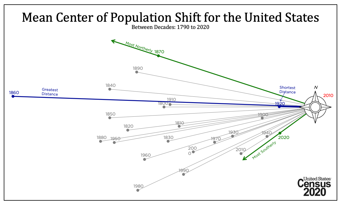
The movement of the population center from 1790 to 2020 is illustrated in Figure 1.
The 2020 center is about 120 miles west-southwest of Missouri’s eastern border, and about 135 miles east-northeast of where the Missouri border meets those of Oklahoma and Arkansas. This more southwesterly direction has become the pattern in the most recent decade. It is about a mile from Missouri state highway 95, about 30 miles from Interstate 44 (St. Louis to Wichita Falls, Texas, northwest of Fort Worth) at Lebanon. The closest municipality is Hartville, located 14.6 miles to the southwest; Fort Leonard Wood is to the northeast of the new population center.
The movement of the population center gives an idea of migration and growth trends, from the first census in 1790 when the population center was in Kent County, on Maryland’s eastern shore, directly across Chesapeake Bay from the city of Baltimore.
The population center moved principally west for nearly two centuries, reaching suburban St. Clair County, Illinois, across the Mississippi River from the city of St. Louis in 1970. It was a 730-mile journey from the eastern shore of the Chesapeake to the east bank of the Mississippi. This movement reflected the westward expansion of the nation. In terms of longitudeversus latitude, the population center moved about 640 miles west and 40 miles south, or 94% to the west and 6% to the south.
More recent the movement to the south has taken on greater significance Between 1970 and 2020, the population center moved 125 miles westward and 62 miles to the south. One third of the population center movement was to the south and two-thirds to the west.
The southern trajectory’s influence has increased in the last decade, moving 9 miles west and 6 miles south. As the crow flies, the population center moved 12 miles, the shortest change between censuses in 100 years.
Probably the largest factor in the southern shift and slower movement west lies in the implosion of population growth in California. The state had experienced the strongest growth in national history, peaking in the 1980s, with an average increase of more than 600,000 residents every year, adding more than a quarter to its population. California’s numeric population growth was the largest of any state in every decade from the 1920s to the 1990s.
By the 2010s, the California momentum stopped. Overall, California added only one-third of its 1980s gain numerically despite a much larger population base in 2010 than in 1980. In the last two years of the decade, California suffered a modest population loss, the first time that has happened since statehood (1850). Further, stronger Southern growth occurred for example in Texas, Florida, Georgia, North Carolina South Carolina and Tennessee increasingly counterbalanced the gains in the west. In the 2000s and the 2010s Texas had the largest population growth, and in the 2010s Florida ranked second, while California ranked third.
The population center has moved only one county in each of the last three censuses. From 1990 to 2000, it moved from Crawford County, Missouri to adjacent Phelps County. Then in 2010, the population center moved to adjacent Texas County and finally in 2020 to adjacent Wright County in 2020.Moreover, the population center has never been in the same county more than once. However, Wright County could keep the center for three censuses, as the current pattern suggests it will wander from the northeastern corner of the county to the southwestern corner.
Finally, the mean population center could remain in Missouri for some time to come. Should the US population continue to grow as it has over the last decade, the population center could take more than 130 years to exit Missouri (into either northeastern Oklahoma or northwestern Arkansas). While further demographics changes could alter the “show-me” state’s population centrality, there is no evidence at this point to indicate such a development.
Wendell Cox is principal of Demographia, an international public policy firm located in the St. Louis metropolitan area. He is a founding senior fellow at the Urban Reform Institute, Houston, a Senior Fellow with the Frontier Centre for Public Policy in Winnipeg and a member of the Advisory Board of the Center for Demographics and Policy at Chapman University in Orange, California. He has served as a visiting professor at the Conservatoire National des Arts et Metiers in Paris. His principal interests are economics, poverty alleviation, demographics, urban policy and transport. He is co-author of the annual Demographia International Housing Affordability Survey and author of Demographia World Urban Areas.
Mayor Tom Bradley appointed him to three terms on the Los Angeles County Transportation Commission (1977-1985) and Speaker of the House Newt Gingrich appointed him to the Amtrak Reform Council, to complete the unexpired term of New Jersey Governor Christine Todd Whitman (1999-2002). He is author of War on the Dream: How Anti-Sprawl Policy Threatens the Quality of Life and Toward More Prosperous Cities: A Framing Essay on Urban Areas, Transport, Planning and the Dimensions of Sustainability.
Photo: Google Earth map with 2020 Census mean population center


