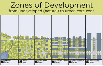
One of the often-used arguments from advocates for increasing housing supply in our nation's most expensive cities is that zoning policy, or the regulation of land use by local government, has kept an artificially low ceiling on housing development, partly enabled by NIMBY homeowners who decry any changes that alter their community character -- or property value. There is quite a bit of truth to this.
But there are two counters to this argument that get little attention. First, there are actual physical, geographical, social limits to development that go unrecognized, or increase the level of difficulty in adding more housing. Second, whether we like it or not, the American preference for development intensity has declined over the decades, leading us to view sprawled development as fully developed.
Taken together, it’s clear that simply lifting restrictive zoning standards alone can’t resolve our nation’s housing affordability crisis.
I first pondered this issue five years ago for Forbes when I found the work of three researchers: Dr.Guangqing Chi, then an associate professor of sociology and demography at Penn State University; Dr. Derrick Ho, then a research fellow from Hong Kong Polytechnic University; and James Beaudoin, a geographical information systems/web developer then with the University of Wisconsin-Madison. Together they created a national land development index that gives us a much better understanding of how much — or how little — land is available for development, down to the county level, throughout the U.S.
The researchers began their project with a simple premise. The amount of developable land in any given area or place is constrained by a variety of factors, some cultural, some legal and many more physical. Obviously, some places are constrained by the amount of surface water that surrounds them, like New York City (Hudson and East rivers, New York Bay, the Atlantic), or Seattle(Puget Sound and Lake Washington). The same could be said about wetlands (Miami and the Everglades), mountains (LosAngeles’ surrounding ranges), or a combination of the three (the Bay Area). Once those constraints are added to existing built-up areas, the amount of developable land in a given area changes dramatically.
Dr. Chi and his team of researchers compiled land data from a vast array of sources to develop an assessment of remaining developable land at the county level for the more than 3,100 counties or county equivalents in the nation. In their analysis they factored out:
- surface water areas;
- wetland areas;
- federal and state-owned lands (parks, forests, preserves, wildlife refuges, fisheries, etc.);
- estimates of steep slope areas (areas with a terrain slope of 20% or more) identified through satellite analysis; and
- analysis of existing built-up land, already occupied and built for human use.
Unfortunately, the most recent data has a baseline year of 2010. But if you click on any county on the nationwide county map on the Land Developability project’s page, you can get a sense of the amount of land available for development once these constraints are factored out. Much of the nation west of the Rockies is particularly constrained due to steep terrain and publicly owned land; numerous counties without heavy development still manage to have less than 20 percent of their land available for development. There are pockets of low developability along the Gulf Coast and in Appalachia. The middle of the nation between Appalachia and the Great Plains is virtually unconstrained.
Read the rest of this piece at Corner Side Yard Blog
Pete Saunders is a writer and researcher whose work focuses on urbanism and public policy. Pete has been the editor/publisher of the Corner Side Yard, an urbanist blog, since 2012. Pete is also an urban affairs contributor to Forbes Magazine's online platform. Pete's writings have been published widely in traditional and internet media outlets, including the feature article in the December 2018 issue of Planning Magazine. Pete has more than twenty years' experience in planning, economic development, and community development, with stops in the public, private and non-profit sectors. He lives in Chicago.
Photo: courtesy Corner Side Yard Blog. Source: transect.org


