
The strange but true geography of the Pacific Ocean has the Tokyo and Honolulu metropolitan areas outer island exurbs more than a thousand miles (1,600 kilometers) away from their urban cores, and a distance between the westernmost and easternmost points in Alaska of more than 2,000 miles (3,200 km), most of it open ocean waters and overlapping most easterly points in the United States.
Kure Atoll: Honolulu’s Westernmost Exurb
Long distances in US counties are not unusual. For example, San Bernardino County is the nation’s largest, with 20,000 square miles (52,000 square km) of land. This is larger than Costa Rica and a quarter larger than Denmark. From the city of Ontario, on the eastern border of Los Angeles County, parts of San Bernardino County are more than 200 miles away (320 km). In third largest Nye County, Nevada (also larger than Denmark) it is possible to drive nearly 300 (480 km) miles from one end to the other. Tonopah is the seat of Nye County. Pahrump is the largest urban area, located on the California border, over Mount Charleston from Las Vegas.
However, the distances in these mainland counties are nothing compared to that of Honolulu County in Hawaii. The maximum breadth of Honolulu County is about seven times that of San Bernardino County. Honolulu County is not large, with only 600 square miles (1,550 square km). More than 30 counties the size of Honolulu could fit in San Bernardino County.
Honolulu County, however, also includes a number of islands to the west, beyond Kauai and Niihau, stretching all the way to Kure Atoll (top photograph and Photo 1), approximately 1,350 miles away (2,200 km).Since the smallest geography in a US metropolitan area is the county and Honolulu County is metropolitan, Kure Atoll is in the Honolulu metropolitan area, as a distant exurb. Kure Atoll is in the Papahanaumokuakea Marine National Monument, which consists of Hawaii’s Leeward Islands (upwind). The large more well known Hawaiian Islands are the Windward Islands (downwind).
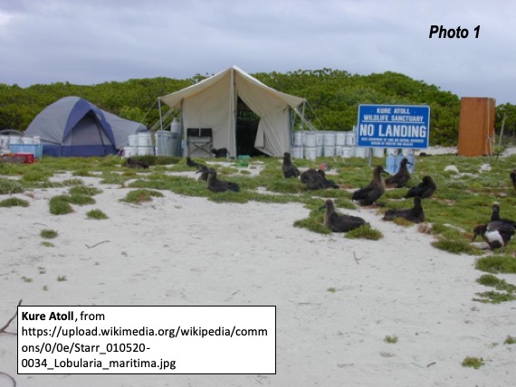
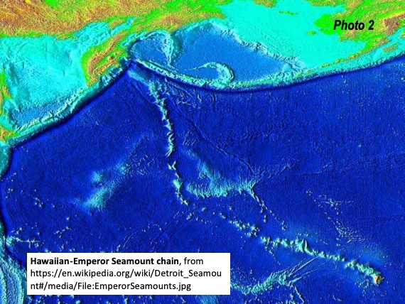
Kure is one of a number of islands that form an undersea mountain range stretching from the Loihi seamount, on the undersea flank of the island of Hawaii’s Mauna Loa volcano to Kure Atoll. the larger islands of Hawaii. The islands, including the well known larger Hawaiian Islands are the tops of seamounts, but many have summits beneath the surface of the water. Less than 100 miles to the east of Kure Atoll is Midway Atoll, site of a one of the most important battles in World War II. Midway, however is not a part of the state of Hawaii, but is under direct federal government administration. Kure Atoll is located at 178 degrees west longitude, only 100 miles from 180 degrees west longitude, which divides the Earth in between east and west longitude.
The Hawaiian seamounts become the Emperor seamounts to the west of Kure Atoll, forming the Hawaiian Islands-Emperor seamount chain (Photo 2) At this point the seamount chain bends from west-northwest to northwest orientation and nearly reach the nation’s westernmost point.
Westernmost Point in the US: Peaked Island, Alaska
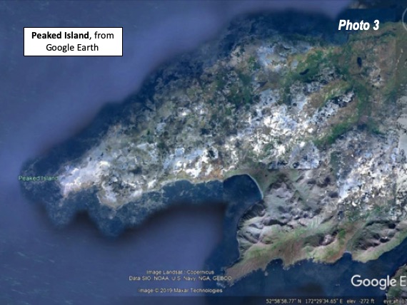
The Hawaiian Emperor-Seamount chain continues nearly all the way from Kure Atoll to the Aleutian Islands. Most of the Emperor seamounts are named for emperors of Japan, but the last is named after the USS Detroit, a US Navy light cruiser that survived the Pearl Harbor attack. Peaked Island (Photo 3), about 200 miles from the Detroit seamount is the farthest point west in the United States, though it is in the Eastern Hemisphere.
After escaping Pearl Harbor, the USS Detroit participated in the Battle of the Aleutians Islands and bombarded positions on the island in the run-up to the joint US and Canadian recapture of the island. The Battle of the Aleutian Islands is less well known than the Battle of Midway, but lasted longer. It started before Midway, and ended later (in 1942).
Aleutians: Most Easterly and Most Westerly Points in the US: A Matter of Definition
Just to complicate things, Conde Naste Traveler notes: “You probably wouldn’t be surprised to hear that the outer Aleutian Islands, stretching between Alaska and Russia, are home to the westernmost point of land in North America. But did you know that the Aleutians can also claim the easternmost point of North America as well?” Conde Naste continues: “Most crucially for geography nerds, the easternmost point of Semisopochnoi Island sits less than ten miles west of the 180-degree meridian that separates the Western Hemisphere from the Eastern Hemisphere. In other words, Semisopochnoi and the dozen or so Aleutian islands lying beyond it are so far west that they’re actually east!” (Photo 4).

Minami - Tori - shima: Exurban Tokyo
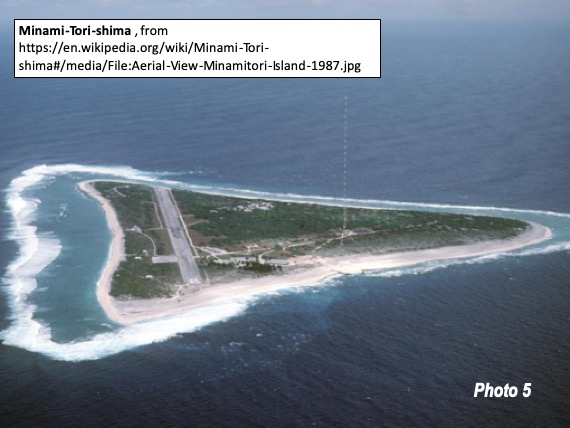
The Tokyo metropolitan area, which by some definitions consists of Tokyo, Kanagawa, Saitama and Chiba prefectures has its own island exurbs, with a number located generally to the south and east. The most remote is Minami-Tori-shima, 1,150 miles (1,900 km) from the Tokyo city center (Photo 5). Further, measured from the extreme exurbs, it is only 1,750 miles from Tokyo to Honolulu (Minami-Tori-shima to Kure Atoll). This is less than one-half the 3,900 miles (6,200 km) between the city centers of Honolulu and Tokyo. Another island suburb of Tokyo is Iwo Jima, home to another classic World War II battle. IwoJima is 750 miles (1,200 kilometers) from central Tokyo.
Alaska: From Peaked Island to Hyder
Back to Alaska, Peaked Island as the western most point in the United States is in the eastern hemisphere Peaked Island is at 172 degrees east longitude, more than 300 miles (480 km) beyond the dividing line of 180 degrees longitude. It is a long way across Alaska from here. The farthest Alaskan point from Peaked Island is on Portland Canal, a fjord on the border between the Alaskan Panhandle and British Columbia, more than 2,250 miles away (3,600 km). This is longer than the airline distance between Los Angeles and Pittsburgh.
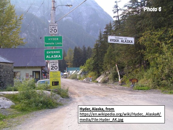
There is no settlement at this point on Portland Canal. However, the hamlet of Hyder (Photo 6) is nearby, with a population of under 100. The only land access to Hyder is through Stewart, British Columbia, on a spur of the Cassier Highway (BC-37), a paved route between the Winnipeg to Prince Rupert Yellowhead Highway (Route 16) and the Alaskan Highway, near Watson Lake, Yukon. Hyder makes it possible to visit Alaska without driving an additional 900 miles (1,400 km) to the Alaska border and farther to Fairbanks, Anchorage or Prudhoe Bay (from Vancouver or Seattle). Of course, not much of Alaska is accessible from Hyder.
Geographic Anomalies
There are many geographic anomalies beyond these few noted in the Pacific Ocean. Many are unaware that Portugal, Morocco and most of Spain and the United Kingdom are in the Western Hemisphere, along with most of the French Atlantic Coast. Or that Reno is west of Los Angeles, due to the shape of the North American continent. There are many more.
Top Photo: Satellite view of Kure Atoll, the western most exurb in the Honolulu metropolitan area. via Wikimedia.
Note: This excludes the boroughs of Alaska, which are the equivalent of county divisions. The largest of these is the unorganized borough, which is 16 times the size of San Bernardino County and larger than both Turkey and Texas. Four organized boroughs are also larger than San Bernardino County.
Wendell Cox is principal of Demographia, an international public policy and demographics firm. He is a Senior Fellow of the Center for Opportunity Urbanism (US), Senior Fellow for Housing Affordability and Municipal Policy for the Frontier Centre for Public Policy (Canada), and a member of the Board of Advisors of the Center for Demographics and Policy at Chapman University (California). He is co-author of the "Demographia International Housing Affordability Survey" and author of "Demographia World Urban Areas" and "War on the Dream: How Anti-Sprawl Policy Threatens the Quality of Life." He was appointed by Mayor Tom Bradley to three terms on the Los Angeles County Transportation Commission, where he served with the leading city and county leadership as the only non-elected member. Speaker of the House of Representatives appointed him to the Amtrak Reform Council. He served as a visiting professor at the Conservatoire National des Arts et Metiers, a national university in Paris.


42nd parallel
You forgot that Canada is south of California.