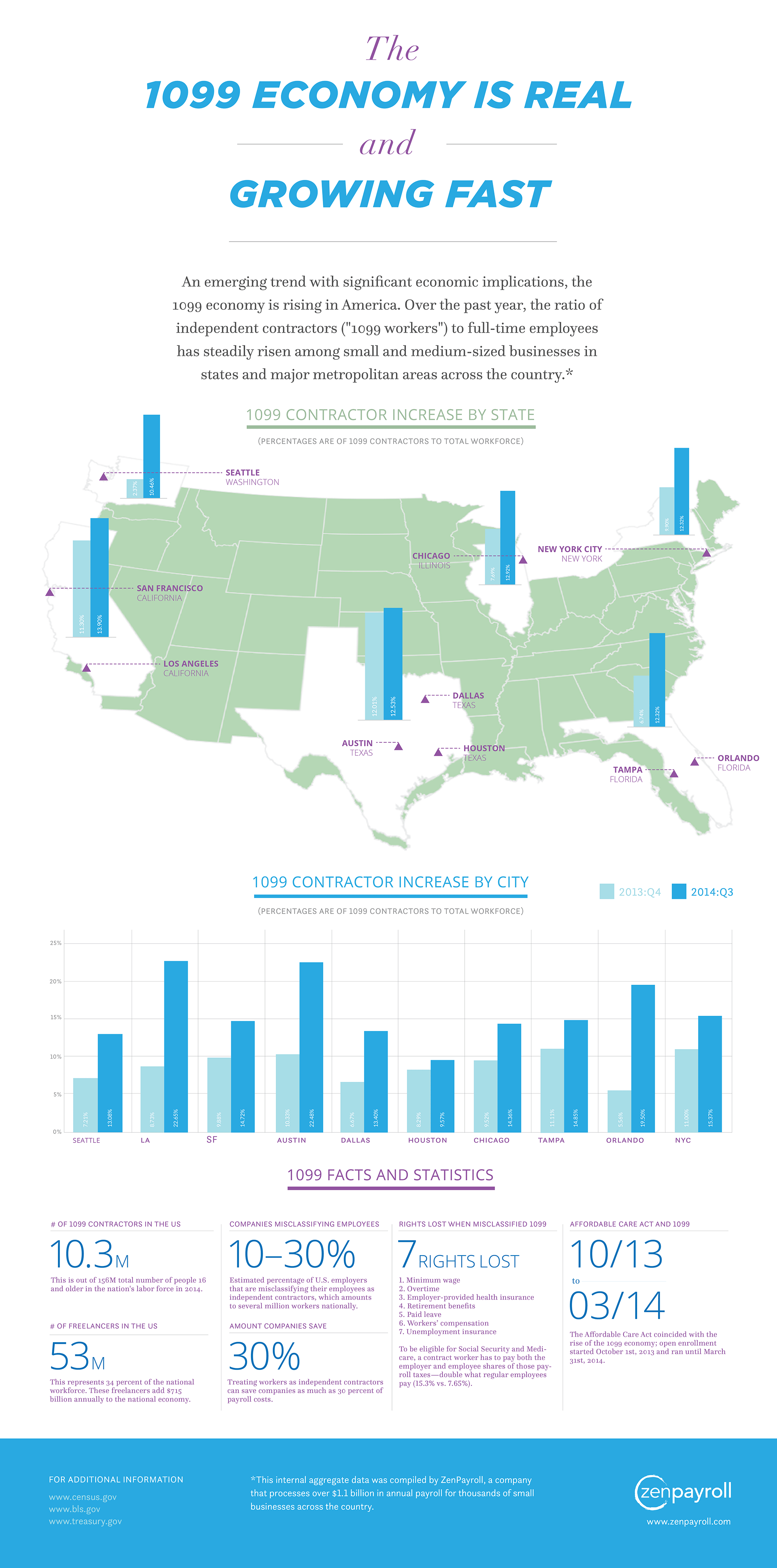
| 
							
							
								NewGeography.com blogs 


    The doubtful claim that low density US cities impose a cost  to the economy of $400 billion is countered by their being the most affluent in  the world. Nine of the top 10 cities in GDP per capita are in the US and more  than 70% of the top 50. The highest GDP per capita city in the world is one of  the least compact, Hartford, with an urban population density among the bottom  10 out of more the than 900 urban areas larger than 500,000 (See here and here).  Mobility is an important driver of economic performance. US  cities have less traffic congestion, and shorter work trip travel times than  their international peers (Los Angeles has the shortest work trip travel times  of any megacity for which there is data). The key to this productivity is more  dispersed residential and employment locations (less than 10% of jobs are  downtown) and the less intense traffic congestion that is associated with such  development. In the US, just as in Western Europe, commuting by car is much  faster than by transit. The coming fuel efficiency improvements will narrow or  eliminate the gap between personal vehicle and transit GHG emissions per  passenger kilometer. US fuel efficiency standards are projected to reduce gross  car GHG emissions by more than a quarter by 2040, according to the US  Department of Energy. That's before any de-carbonization. The US has some of the best housing affordability in the  world (excluding cities like San Francisco and Portland, where politically  correct policies raise prices, lowering the standard of living and increasing  poverty). The miniscule  reductions from favored urban policies are exceedingly expensive per tonne  and incapable  of making a serious contribution to GHG emission reduction. Maintaining the standard of living and reducing  poverty requires cities that are mobile and affordable. It is important that  GHG emissions reductions be chosen for their cost effectiveness, rather than  consistency with expensive academic theories that long predate GHG emissions  reduction concerns. This piece was posted  to comments at The Economist. 
        	
    
        by Anonymous 08/13/2014
     What’s often forgotten in politics and governance is  municipalities are the creation of state legislatures.  A good deal of the population growth in major  cities in the second half of the nineteenth century was due to annexation. One  of the best examples is New York‘s amazing growth due to annexing Brooklyn. Few people are talking about  it but it’s time to consider smaller political units. As Detroit struggles with  failure of bankruptcy, the geographical size of the Motor city is becoming a  major issue. Detroit’s long decline eventually put it a federal  bankruptcy court. The reasons are numerous but the reality is here.  How Detroit exists from bankruptcy court is  now an issue. Putting Detroit on a sound economic footing is essential to  preventing another bankruptcy. The  Detroit Free Press reports: 
The investment banker representing the City of Detroit had talks with billionaire real estate  investor Sam Zell and investment firm the Blackstone Group about selling them  the city’s vacant property — but the investors weren’t interested, the Free  Press has learned.
 The revelation comes as the value  of Detroit’s abandoned and blighted property — which the city considers assets  in its Chapter 9 bankruptcy — is in dispute.
 Creditors argue that city-owned  property is a source of significant value that is being ignored in the city’s  bankruptcy restructuring blueprint, called a “plan of adjustment.” The  creditors argue the approximately 22 square miles of vacant or blighted  property the city owns could be sold — with the proceeds distributed to  creditors and even reinvested in the city.
 But Ken Buckfire, president of the  city’s investment banking adviser Miller Buckfire, testified that city-owned land “to some extent has  negative value,” according to a deposition transcript obtained by the Free  Press. One way to interpret the comment about “negative value” is where  the land is located. If Michigan’s state legislature re-drew Detroit‘s  geographical boundaries, investors would be more interested in the land. A new  municipality, without Detroit’s corrupt and expensive politics would be a major  reform. Detroit as it exists today isn’t  viable for job growth and a stable population. Detroit’s local politicians and  special interest groups would obviously fight any changes in geographical boundaries  in Michigan’s state legislature because a declining Detroit was a way to  plunder taxpayers. But Michigan  taxpayers need to start asking themselves: is Detroit’s 143 square miles a  viable long term enterprise? 


    Maps have been published illustrating the City Sector Model  functional urban classifications for the 52 major metropolitan areas in the  United States. The maps are available at Demographia City Sector Model Metropolitan Area Maps. Functional  Classifications of Metropolitan Areas The City Sector Model allows a more representative functional analysis of urban core, suburban and exurban areas, by the use of  smaller areas, rather than municipal boundaries.  The nearly 9,000 zip code tabulation areas of major  metropolitan areas are categorized by functional characteristics, including  urban form, density and travel behavior. There are four functional  classifications, the urban core, earlier suburban areas, later suburban areas  and exurban areas. The urban cores have higher densities, older housing and  substantially greater reliance on transit, similar to the urban cores that  preceded the great automobile oriented suburbanization that followed World War  II. Exurban areas are beyond the built up urban areas. The suburban areas  constitute the balance of the major metropolitan areas. Earlier suburbs include  areas with a median house construction date before 1980. Later suburban areas  have later median house construction dates.  


    A New York Times article by Sam Roberts indicates that 
 
"According to Census Bureau estimates released  last week, in the year  ending July 1, 2013, the city recorded the third consecutive gain in its  non-Hispanic white population.
 During that same period, the city gained more people than it lost  through migration. Neither of those gains has probably happened since the  1960s, according to demographers."
 It is  true that net migration, domestic and international, was positive between 2012  and 2013. However, net migration was also positive in the years ended 2012 and  2011, according to Census Bureau data.   Among the three recent years, the lowest net migration total was in 2013  (Table). 


| New York City Net Migration: 2011-2013 |  
| Year | Domestic | International | Combined |  
| 2011 | (55,807) | 69,076 | 13,269 |  
| 2012 | (64,383) | 71,752 | 7,369 |  
| 2013 | (67,629) | 73,615 | 5,986 |  
| Total | (187,819) | 214,443 | 26,624 |  
| Data from    Census Bureau |  |  
 Further,  net domestic migration has continued to be negative. The city has lost a net  187,000 domestic migrants in the first three years of the decade. This is an  average of more than 60,000 annually. This is, however, an improvement from the  2000s, when net domestic migration averaged a minus 135,000. 


    Today, there are about 30 megacities in the world, where  more than 10 million residents live. The largest is Tokyo, at about 38 million.  Recent announcements by the government of China could lead to the worlds' first  gigacity (for want of a better term, used here to denote a city of more than  100,000,000 population, see note). According to the Nanfang  Insider, the economic integration of megacity Beijing, megacity Tianjin and  eight cities (prefectures) in the province of Hebei would result in a city of  130 million. China Daily is a bit more  circumspect, indicating that the Beijing supercity would have only 85 million.  The giga/super city would be tied together by new rapid  transit lines and highways and surrounded by the 7th Ring Road, adding to the  six that have already been built. The 7th Ring Road would consist of two roads,  circling most of the area, and extending to a combined 850 miles (2,200  kilometers). By comparison, London's M-25 is 117 miles long (188 kilometers),  the Moscow MKAD 68 miles long (109 kilometers) and the Washington beltway is 64  miles long (103 kilometers) The giga or super city is not likely to really be a city,  because it would be much larger than a labor market (this is why the near  continuous urbanization from Boston to Washington or Tokyo to Osaka-Kobe-Kyoto  is not a city). The estimated land area is 67,000 square miles (175,000 square  kilometers). This is nearly as large as Cambodia or the state of Oklahoma.  Providing the point to point daily commuting in such a large area is well  beyond the capability of any affordable transportation system. Star Trek like teleportation could do  the trick. Meanwhile, however, there is plenty to be gained from the economic  integration of this large area. Graphic of the new 7th ring road from nanfang.com: 
 
 Note: Technically, a gigacity would need 1 billion people (10 to the 9th power). However, megacities, with their 10 million minimum are  also wrongly named. A city with a mega city would have 1,000,000 people (10 to  the 6th power). Artistic license justifies the gigacity term under the circumstances.  Besides, with the slowing growth of world population, it seems unlikely than  any city will achieve a population of 1 trillion. |