
Freeways, particularly urban freeways, have had a bad press for several decades now. They are accused of despoiling scenery, destroying habitat and causing urban sprawl. Many observers report with glee on the latest news of a small segment of urban freeway being dismantled.
This blanket condemnation makes it easy to overlook the remarkable contribution that these freeways have made to the American economy and to American culture. It is hard to imagine the growth in productivity in the country during the postwar years without these roads, which vastly increased the mobility of goods and people and connected parts of the country together in ways that were unprecedented.
The constant criticism also makes it difficult to appreciate these roads as cultural artifacts and a wonderful way to see the country. This is all the more surprising since Americans in recent years have been discovering the rich legacy of our nation’s highways. There has been spate of books that celebrate travel on America’s pre-freeway-era highways. Many authors wax eloquent over the remaining motels, fast food restaurants and drive in theatres along US 66 or advise motorists on finding abandoned segments of roadway by passed by later highway alignments. There has also been a remarkable surge of interest in America’s parkways, from the earliest parkways like the Bronx River Parkway in Westchester County New York, started in 1907, to parkways at the end of the parkway era in the years immediately before and after World War II when they gradually became more like freeways, for example the Arroyo Seco Parkway in Los Angeles, or the later segments of Lake Shore Drive in Chicago, the Taconic Parkway in New York State or the George Washington Parkway outside Washington.
America’s postwar freeways merit a similar rediscovery. I think that one of the biggest obstacles to appreciating them has been a question of scale. Driving along a two-lane roadway it is possible to pull off the pavement and look at an historic courthouse or a particularly interesting agricultural landscape or early gasoline station. That is not possible on a freeway. It is also true that the engineers who designed the nation’s postwar freeways were probably less conscious of the aesthetic dimensions of the roadways than the designers of the German autobahn, who set a standard for integration of landscape and roadway never surpassed, or American designers like landscape architect Gilmore Clarke who played important role in designing the parkways of metropolitan New York. There is, moreover, no doubt that the push to accommodate increasing traffic loads and to make freeways safer in this country has led to a certain uniformity of standards that some people find boring. Finally, the proliferation of sound walls over the last few decades all too often makes driving through urban areas like driving through a tunnel.
Still, there is no better way to get a good view of the larger features of the American landscape or cityscape than looking through the windshield of an automobile rolling along a freeway at 65 miles per hour. At that speed it is often easier than on a slower road to appreciate the changes that occur in plant species as the highway climbs a steep ridge or to appreciate the way massive cuts to lower the grades on the climb over a hill that provide a graphic illustration of the underlying geology. It might be difficult for many people to appreciate long stretches of flat country but, if a driver can put herself into the proper frame of mind, this experience can have its own rewards because of the way it accentuates the scale of the landscape. Even the billboards, which many drivers consider simply objectionable intrusions into the natural landscape, can, by their style and content, illustrate a great many regional differences.
And fortunately, there has been over the last two decades a growing recognition of the aesthetic dimensions of freeways. In some ways this marks a reversion to ideas that were common in the parkway era when there was almost always a conscious attempt to integrate road and landscape into a successful composition reflecting the landscape and culture of the region through which it passed.
A pioneer postwar example of this push to bring conscious aesthetic design to the freeway can be seen in I-280, the Junipero Serra freeway, which runs between San Francisco and San Jose. Here the engineers worked with Lawrence Halprin, the landscape architect, and architect Mario Ciampi to create a road that was widely considered the “most beautiful freeway in the world” when the initial segment was opened in the 1960s. This highway, with its careful alignment, minimizing cut and fill, and the bold, sculptural concrete overpasses does little to diminish the spectacular landscape of the San Francisco Peninsula. In fact it affords a wonderful way to experience the golden hills on one side of the roadway and the coastal range on the other, often seen in the morning or late afternoon with fog pouring over the crest.
In recent years the highway departments in an increasing number of American states have attempted to be more attuned to the aesthetic dimensions of freeways and of the places through which the roads run. Wildflowers now bloom in medians and margins of a great many American freeways. In arid landscapes engineers and landscape architects have worked to preserve native plants and use them as elements in a kind of idealized desert landscape in the median and along the berms. In one of the most impressive achievements, a twelve mile stretch of I-70 passing through the tortuously narrow Glenwood Canyon west of Denver, opened in 1992, the designers went to great length to fit the roadway into the landscape in the least obtrusive way possible. They accomplished this by splitting the roadway alignments, reducing the section of the roadway structure to a minimum, cantilevering both alignments from the canyon walls to reduce their bulk, pushing tunnels through the most difficult spurs of land and even treating the rocks that were scarred by excavation so they would not produce jarring juxtapositions.
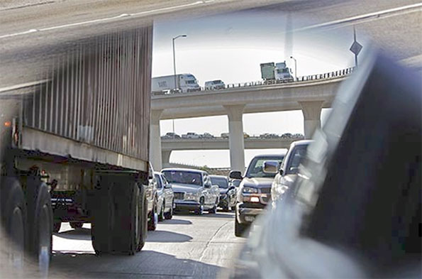
Even the urban freeway, target of the most vociferous criticism, offers interesting perspectives for those willing to look. Unlike the case in much of Europe, where planners have often attempted to create a parkway-like driving experience by providing a wide buffer between the roadway and nearby urban areas and tightly restricting new development along the highways, American freeways have become the new main streets of many cities. Driving along the ring roads around American’s large cities can offer some of the most compelling views of these metropolitan areas. For the motorist driving along I-80, the Ohio Turnpike, there is the view from the giant viaduct crossing the Cuyahoga River. There, 20 miles to the north, up the heavily wooded deep gash created by the river, the gleaming tip of the Key Bank Building peaks out above the intervening ridges in clear weather, unfortunately all too rare in Northeast Ohio. Likewise, very few urban views can compare with the panorama that suddenly unfolds for motorists as, emerging from I-376’s Fort Pitt Tunnel under Mount Washington, they suddenly burst out onto a bridge over the Monongahela River and a view of the Golden Triangle and the entire skyline of Pittsburgh.
A drive along a city’s freeways is often the best way to get a good grasp of a region’s economic geography. It would be hard to miss the contrast between the view from the Indiana Toll Road across the grimy industrial landscape of steel mills and refineries just east of Chicago, on the one hand, with the landscape of heavily planted berms and expensive new houses along the Tri-State Expressway in the north suburbs.
Many of the earliest freeways have crossed the 50 year threshold and deserve a closer look as some of the country’s most important historical and cultural artifacts. And they provide a wonderful way to observe America’s landscape and cityscape.

Taconic State Parkway north of New York City. The New York area had the first and largest set of parkways in the nation. The Taconic, running along the Taconic Mountains from the Kensico Dam in Westchester County to Chatham near Albany, was not finished until 1960, but it maintains the earlier parkway standards rather than those of the later freeway era. Because of its careful alignment and roadway design by landscape architect Gilmore Clarke and the beauty of the rugged countryside which it runs, it remains one of the country’s great driving experiences.

I-280, Junipero Serra freeway, south of San Francisco. Although a much wider highway than the prewar parkways, this road, constructed in the 1960s, maintains much of the feel of the earlier parkways though the use of alignments carefully fitted into the rolling hills, integrating the road beautifully into the spectacular landscape of the San Francisco peninsula.

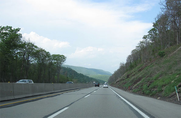
I-20 east of Birmingham Alabama. The undulating line that marks the edge of the pine forest and the beginning of the mowed grass in the freeway margins recalls the long curving vistas of English 18th century picturesque landscape tradition. On an overcast morning the resemblance to the British landscape tradition is particularly striking.
I-10 and I-215 at Colton, California. No place in the United States is so associated with freeways as the Los Angeles region, but actually this region has fewer lane miles of freeway than most large American metropolitan areas. Because freeway construction pretty much stopped in the 1970s but the population continued to grow and the density rose, this region has some of the most congested roads in the country. If there is any consolation, they offer some remarkable displays of engineering bravado and urban intensity.
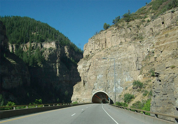
I-70 west of Denver, Colorado. The construction of this roadway through the Glenwood Canyon in the Rockies is both an engineering feat and an aesthetic tour de force. By separating the alignments and cantilevering the roadway from the canyon wall, the designers were able to minimize the visual impact of the road and provide spectacular vistas for travelers.
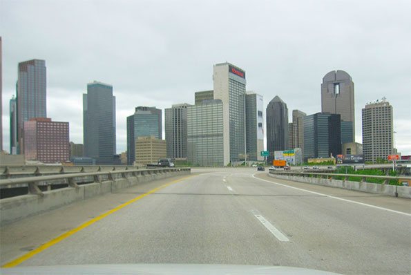
US 75 approaching downtown Dallas. This short piece of roadway completes a loop around downtown Dallas that allows two interstate roads to bypass downtown. A drive around the loop provides a kaleidoscopic sequence of views of tall buildings and a highly effective orientation to downtown Dallas.
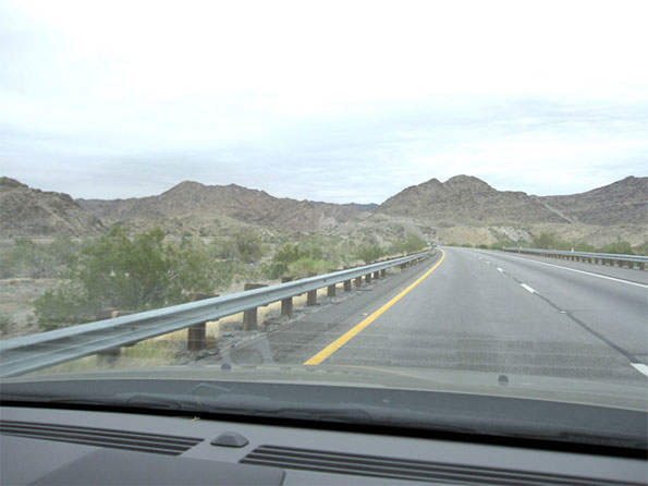
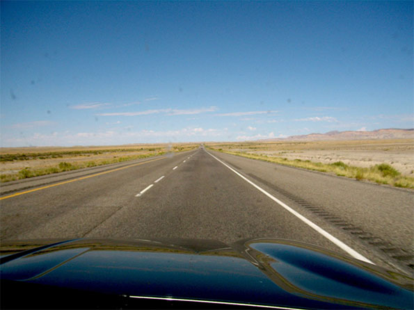
I-10 east of Blythe Arizona. Perhaps even more than in the East, the great distances of the American West make the freeway a lifeline for residents who live far from population centers. The smooth roadway makes a striking contrast with the great rock outcrops and vast stretches of scrubland.
I-80 and I-94 Pennsylvania Turnpike north of Pittsburgh. The era of the parkway ended at about the time of the second world war as a new generation of freeways started to emerge. One of the interesting features of the interstate system today is the way it provides testimony to the shifting ideals of roadway design. Although large stretches of the Pennsylvania turnpike, whose initial segment opened in 1940, have been upgraded, the narrow right of ways and steep gradients of the older portions of the road as well as the streamlined design of the overpasses recall the transition from one age to the next.
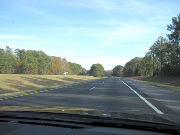
I-20 between Covington and Augusta Georgia. A classic piece of interstate road with the smooth ribbon of pavement gliding effortlessly through a landscape of low hills and dense forest.
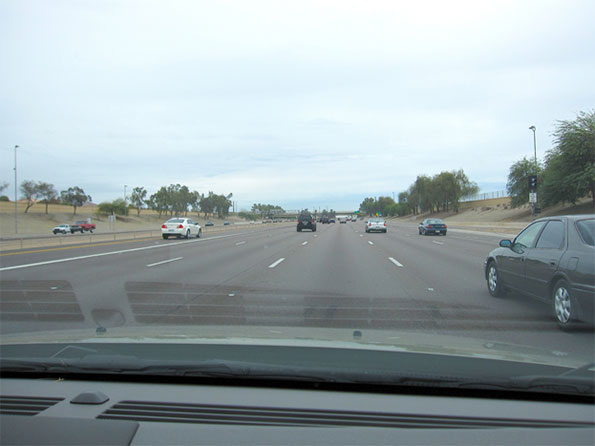
I-10 west of downtown Phoenix. The state of Arizona has been particularly active in trying to create an appropriate landscape for the state’s highways. They have pioneered techniques for saving cacti and other native species in the path of the roadway and then re-installing them alongside the new roads to create an idealized desert landscape.
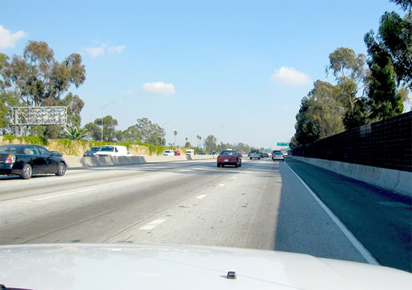
I-10 approaching downtown Los Angeles, California. The advent of sound walls has changed the driving experience in some profound ways. In places it has severed the visual connection between the roadway and the city around it. On the other hand, in some places, as here, when vines and other plants grow up over the walls and trees overtop them, the result is a curious but not entirely unpleasant sensation of floating through a city without being part of it. Until the traffic backs up, of course.

I-27 between Amarillo and Lubbock, Texas. The long flat stretches of the Llano Estacado of northwest Texas produce an almost hypnotic effect. Even highway signs and telephone poles take on a monumental character, and train elevators loom up in the distance like the skyline of a great city.
I-70 in eastern Utah. Although freeways can seem intrusive and over-scaled in the city, they are often dwarfed by the huge open spaces in states like Utah or Nevada.
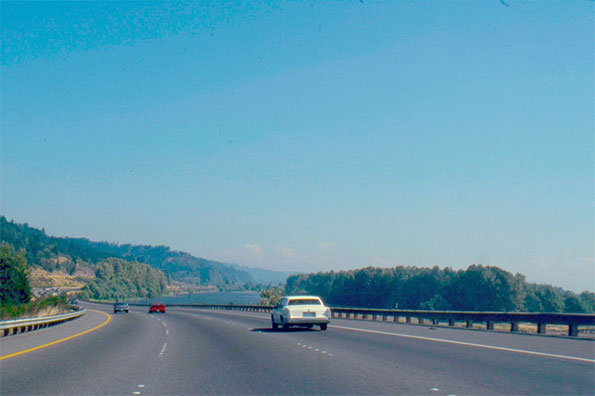
I-5 south of Longview, Washington. A trip across the country on the interstate roadway system allows for a panoramic view of the regional differences between, for example, the flat, semi-tropical landscape of central Florida and the deep green evergreen forests of the Pacific Northwest.
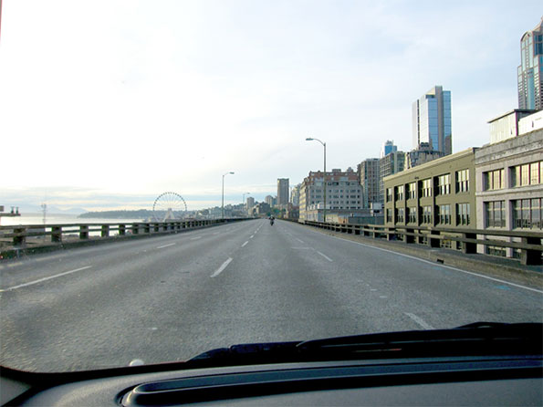
State route 99, the Alaskan Way Viaduct, downtown Seattle. Completed in 1953, this roadway, this roadway like a number of freeways built in the heart of American cities, created a barrier in the city. Some of these highways, for example the Central Artery in Boston have been relocated underground. In other cases, like the Embarcadero Freeway in San Francisco the replacement was a surface boulevard. In this case, after a considerable debate, officials made the decision to create a massive tunnel. It is difficult to argue that a road like this should be preserved, given its structural problems and the way it cuts off Seattle from its waterfront. Still, it is almost inevitable that some of the drivers navigating the new tunnel will keenly miss the spectacular urban spectacle that unfolds today as they sweep along the viaduct.
Robert Bruegmann is professor emeritus of Art history, Architecture and Urban Planning at the University of Illinois at Chicago.


Arroyo Seco
I believe it is now labelled as a scenic parkway, but the Arroyo Seco Parkway (formerly Pasadena Freeway) is absolutely beautiful through Elysian Park with panoramic views of the glassy Los Angeles skyline. There truly is a "tada" moment as you climb over a slight hill and the whole of Los Angeles majestically soars above the Figueroa Street Tunnels. And the art deco detailings along the way are eyegasmic.
http://en.wikipedia.org/wiki/File:FigueroaStTunnels.jpg
http://www.flickr.com/photos/raymondyue/5425701553/
What about the suburban neighborhood the freeway cuts through?
A few years ago my neighbors were up in arms at the unfunded in tax hating NH vague plan to run a freeway through our neighborhood - they were ready to file lawsuits to stop it or to require their properties be bought simply because the freeway sounds would ruin their property value even if they couldn't see it
Many highways built in the 50s especially were run through urban areas by drawing a line straight through the working class neighborhoods, without regard to the communities they cut apart.
Today, suburban freeways are lined with noise barriers, even for developments built decades after the original rural highway, which was expanded to freeway class to handle all the commuter traffic the suburban not-master-plan development created.
Here in NH, the master plans proposed in the 70s were opposed but the development occurred without the plans and without the freeways the master plans called for, so the rural roads get belatedly expanded to handle the traffic, encroaching on the property that was built originally well setback from a country road.
Of course, the scenic freeways above that are of originally rural Interstate were all part of a master plan that involved rather expensive rules dictating the land area occupied by the right of way, with planners purposely skirting small urban cities to speed development and reduce costs. I lived on US 40 in Richmond Indiana which was the National Highway with lots of services for travelers along the way, but with I-70 skirting the city and speeding tourists past the city that had for centuries been a major stop for travelers.
Of course, the scenic highways are a reflection of the same esthetic that created the Parkways around NYC which were designed for cars only and designed to be scenic auto roads Trucks are excluded for esthetic and pleasure reasons on the parkways.
And a big reason for the esthetics is the dictates from Washington, like the near total ban on highway signs. Other reasons are the impact of the EIS process that creates the many obstacles to building freeways cheap and fast like in the 50s. The Big Dig was all about the esthetics - the centuries of historic building had to be preserved while greatly improving the traffic capacity, while reversing the damage of building cheap and fast without regard to the damage to the communities, not to mention the ugly view that this created as you spend past communities so obviously ripped apart.
The most important aspect of the highways is the willingness of society then to pay for building and maintaining the highways. For the past two decades, the biggest obstacle to building highways is the refusal to tax. Transportation taxes have fallen in real terms for two decades even as the bridges built in the 50s and 60s are reaching and passing their 40-60 year design life.
To have scenic highways you must pay the higher cost, but no one today is willing to pay for cheap ugly while demanding high class luxury
An error and some other useful information
The Pennsylvania Turnpike north of Pittsburgh is signed as I-76, not I-80 or I-94.
Currently, a lot of work is being done to reconstruct and widen the Pennsylvania Turnpike across the state. It's now a six-lane highway from mileposts 2-12, 31-38, 48-50 and 67-75, and work is now underway from mileposts 12-14 and 40-48. Mileposts 28-31 and 57-67 are in final design, and mileposts 50-57 are in preliminary design. And this is just in the Pittsburgh area. There's also a lot of reconstruction and widening happening in the Harrisburg and Philadelphia areas.
Unfortunately, mileposts 38-40 will have to be rebuilt a second time because they were rebuilt before the Pennsylvania Turnpike Commission decided to widen the entire highway to six lanes. As a result, that segment is still only four lanes. A couple of overpasses will have to be rebuilt to accommodate six lanes under them, and the interior shoulders will have to be expanded from 4' to at least 10' in each direction, per AASHTO standards.
A list of all current and near-future construction projects along the Pennsylvania Turnpike can be found here.
great shots,,, so nice
great shots,,, so nice seeing the beauty of the road where every day we passes by and not noticing that the roads hold a beauty where we the locals must be proud of.. credits to the person who notice the beauty of the beauty of our freeway.
get real facebook fan
Pictures that convey 1000 words
Most of the rest of the world has been comforting itself with a stupid myth that "we have avoided American style sprawl and traffic congestion" - therefore the images above will startle many non-American readers at the sheer lack of traffic on the stretches of highway portrayed. This would be rare even at the most off-peak times of daylight in any city in the UK, Europe, Canada, Australia or New Zealand.
The truth is that "avoiding American style sprawl" and "investing in public transport instead of roads" has caused far worse traffic congestion, and almost nobody anywhere in the world has woken up to this yet. Americans themselves still grizzle about how bad they've got it. They should read the TomTom Annual Congestion Index reports and thank their lucky stars they haven't got congestion like British, or European, or Canadian, or Australian, or New Zealand cities. And all those other people should wake up to the stupidity of their own policy approaches.
Embarcadero Freeway
I miss the Embarcadero Freeway in San Francisco, as a kid when my parents took me to San Francisco, it left an impression on me
More San Digo
Also in San Diego, Ca 52, from the 805 to La Jolla, is one of the most beautiful freeways in the state, running through a canyon that is a nature park.
I mean San Diego. Sorry.
I mean San Diego. Sorry.
Favorite Freeway
Lately, I've come to appreciate California Hwy 163 in San Diego going south through Balboa Park. When the freeway dumps the driver on the doorstep of Downtown, it is spectacular, especially at night.