
Most readers may not be initially very interested in the detailed geography of “class” in Seattle, but it actually matters not only for our area but for the whole debate over the shape of the urban future. Academics, perhaps Americans in general, are loath to admit to class differences, yet they remain very crucial to the understanding of how cities and regions evolve.
Seattle is a great example of the transformation of a 20th century model of the American metropolis to a 21st century-cum-19th century “old World” model of metropolis. It is often held up as one of the role models for other cities, so its experiences should be considered seriously not only for American cities but for regions throughout the advanced world.
Many readers, including those afflicted with political correctness, probably many upper and lower class folk uncomfortable with their home areas being labeled as of a particular class, or others, might feel that class is an obsolete Marxist term. They may prefer I use the safer term “socio-economic status” rather than “class.” Let’s admit it: “class” is used widely, as in “the middle class is getting squeezed” or the “tax burden on the lower classes.” As it has been for hundreds of years, class remains a meaningful descriptor of areas of obviously differing well-being.
We should understand by identifying upper or middle or lower classes this does not imply “better than.” Class simply reflects the mix of inheritance, education, biology, experience, discrimination, and life events that lead to variability in economic well-being. Class is real. But there is certainly a legitimate concern with the identification of heterogeneous areas like census tracts as of a particular class, based on average or median values for the in fact diverse households in a tract. This method is far from perfect but nevertheless we and others find such generalization common, meaningful and useful.
This map plots “factor scores,” a statistically constructed variable or index divided into six levels of “class:” two upper, two middle and two lower. It is timely to do this, since it was 50 years ago when Calvin Schmid, demographer in Sociology at the University of Washington, and my early mentor, performed a pioneering factor analysis of crime in Seattle – and this was before modern computers! The derived scores most reflect high weighting of the variables: percent of adults with a BA or more, percent in professional versus laboring occupations, median house value and median household income.
As you look at the map, it’s clear how Seattle reflects very strongly what is generally described as gentrification. This means the reclaiming of the central core by the highly educated and professional, eschewing the suburban metaphorical desert. In the case of Seattle, this process occurring between 1985-2005 resulted in the displacement of over 50,000 less affluent and often minority households to south King county. The city begins to resemble the historic pattern of the rich and important occupying the vibrant core of the city, relegating the working poor to the suburbs, with poor access and inadequate services. Indeed, even now I am involved in a project to assess the lack of access of poor children, often minority or foreign born, to health care in south King county.
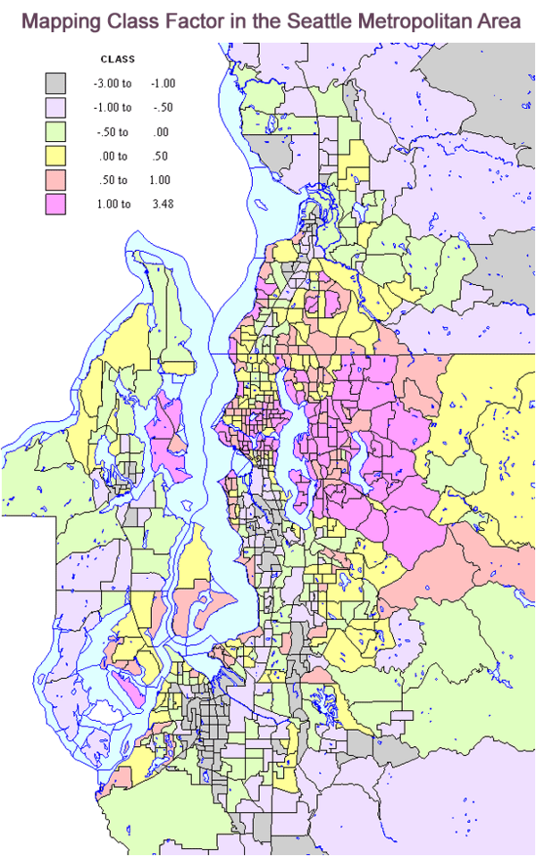
The dominant “upper class” area is the Eastside, east of Lake Washington, and location of the affluent “edge city” of Bellevue, home of the Microsoft campus. A second set of upper class areas are waterfront and view neighborhoods, taking advantage of the Seattle area’s broken topography. The third is simply the University of Washington immediate hinterland. I suspect the location of a large research university with 42,000 students and 22,000 staff increasingly propels Seattle’s unusually high status, income and popularity. I think this is increasingly more important a factor than the presence of an increasingly less important downtown Seattle business center.
Conversely, lower class areas include traditional zones of mixed housing, industry and transport, such as south Seattle, the older satellite cities of Everett (north), Bremerton (west), and especially Tacoma (south). The largest area of lower class neighborhoods extends from south Seattle through south King county to Tacoma, marked by historical development, displacement from Seattle and high minority population. The second large zone of lower class settlement is the rural fringe, especially in Pierce (south) and Snohomish (north) counties, and may surprise those who think all rural areas are the home of rich estates.
Then there is the middle class. This is where the suburbs matter most. On the map, middle class areas (yellow and green) are intermediate in location as well and dominate the outer suburban areas as well as some older inner neighborhoods of Seattle and Tacoma. It is unfortunately true that race, ethnicity and class remain highly correlated especially within the core cities of Seattle and Tacoma, reflecting the continuing history of unequal education and job preparation and prospects.
This analysis suggests one possible future of urban development following something of a European model, with most middle class people in the suburbs, while the rich and poor concentrate either in the urban core or in selected locales in the periphery. As for the city itself, it’s clear that the total landscape is not simply becoming wealthier but increasingly bifurcated between the affluent and the long-term poverty population. And suburbia, home to the vast majority of the region’s population remains the predominant home of the middle and working classes, with pockets of both wealth and poverty.
Richard Morrill is Professor Emeritus of Geography and Environmental Studies, University of Washington. His research interests include: political geography (voting behavior, redistricting, local governance), population/demography/settlement/migration, urban geography and planning, urban transportation (i.e., old fashioned generalist)


Impact of GMA
I'm curious if you had any observations on the impact of the Growth Management Act on these settlement patterns. I've grown up in the region and been involved in local government for some time now, so I have just enough background to make me dangerous.
That said, I was thinking that restrictions on further urban development into the exurbs may have reversed previous trends from the 70's and 80's that saw the "upper class" in Seattle moving out. I can remember seeing condos being built in downtown while a UW student in the mid 90's and thinking it absurd that anyone would end up buying them. Of course now that seems silly with people returning to urban developments.
A larger map
with a legend would have been helpful.
Ooh. Much better.
Dave Barnes
+1.303.744.9024
http://www.MarketingTactics.com