Los Angeles has been restored to the position of densest major urban area (over 1,000,000 population) in the nation, according to Census Bureau data (complete file). The original announcement of urban area population and densities has been revised for the San Francisco-Oakland urban area (San Francisco urban area), which had been listed as the densest major urban area, passing the Los Angeles urban area. Los Angeles had been the nation’s densest urban area in the 1990, 2000 and 2010 censuses and has now been recognized as densest in the 2020 Census.
The previous newgeography.com article summarizing the new data has been revised, with a new table listing the 83 urban areas with more than 500,000 population shown in both this article and the previous (Note 1).
The Revision
The revision places San Rafael-Novato in the San Francisco-Oakland urban area, as it had been in 2000 and 2010. The San Francisco-Oakland urban area had a revised population of 3,516,000, in a land area of 514 square miles, for a density of 6,843 per square mile (2,632 per square kilometer), an increase of 9.2% from the 6,266 reported for 2010, disregarding the changed urban area qualification criteria (Note 2). San Francisco’s 14th ranking in population is unchanged, and even with the additional population has been passed by the Seattle urban area, with 3,544,000 residents. Since 2010, the Seattle urban area grew by 15.8%, more than double the San Francisco gain of 7.2%. During the same period, the land area of the San Francisco urban area declined 1.9%.
There are six smaller urban areas denser than Los Angeles, the largest of which is Arvin, California, in Kern County, about 100 miles north of the Los Angeles central business district. The Arvin urban area had 19.385 residents in 2020.
The Los Angeles urban population density was 7.476 per square mile (2,876 per square kilometer), a 6.8% increase from the 2010 figure of 6,999. The population rose 0.7%, while the land area was reduced 5.7%, with the urban area criteria changes between the 2010 and 2020 censuses. The densest urban area was Mecca, California, located in Riverside County, east of Palm Springs and about 140 miles east of the Los Angeles central business district. Mecca had a density of 10,979.
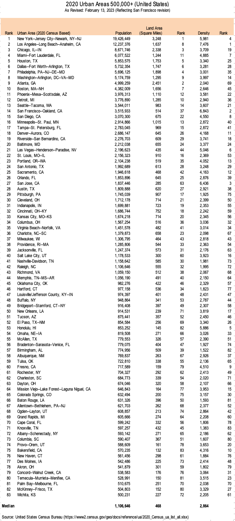
Six of the 10 densest urban areas with more than 500,000 residents are in California (Los Angeles, San Francisco, San Diego, Fresno and Bakersfield, as well as nearby Las Vegas (Figure 1)
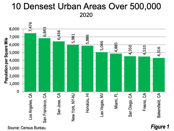
The Census Bureau has published a new 2020 urban area map (zooming on the Census Bureau site makes it possible to visualize virtually major urban areas and more), which reflects the latest data (Figure 2).
The Densest Major Urban Areas
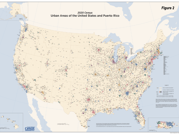
As noted above, Los Angeles begins its fourth decade as the nation’s densest major urban area. With significant changes to urban area criteria, the Los Angeles urban area reported density rose from 5,800 in 1990 to the present 7,476. The San Francisco urban area density rose over the same period from 4,009 to 6,843. The San Jose urban area, with only a tiny urban core surrounded by automobile oriented suburbs, ranked third densest among the majors, with 6,426. New York ranked fourth in 2020, with a density of 5,989 per square mile, up from the 1990 figure of 5,552.
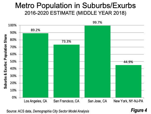
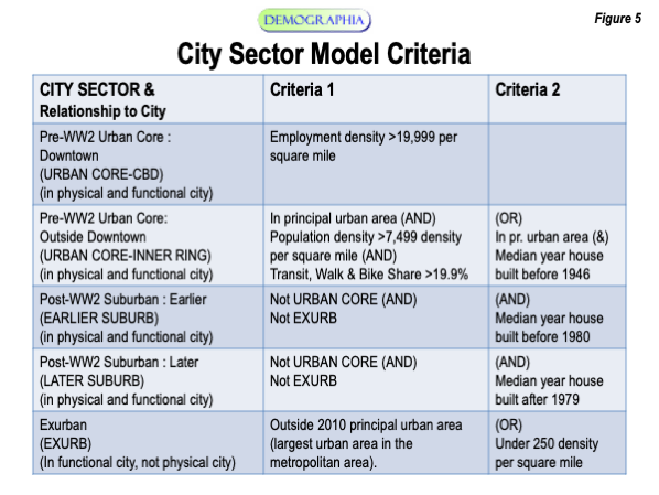
The last four decade history of density among the top four (Los Angeles, San Francisco, San Jose and New York) is illustrated in Figure 3. Perhaps surprisingly, these four urban areas range from one of the most suburban (San Jose) to the least suburban (New York). The four corresponding metropolitan areas are illustrated (Figure 4) with the estimated 2018 share of their population (using the Demographia City Sector Model, described in Figure 5) located in the suburbs and exurbs (outside the urban core). San Jose, which is 99.7% suburban or exurban is a genuine anomaly, especially in comparison with New York having by far the densest urban core in the nation and likely denser than any major urban area in the high-income world with the exception of Hong Kong.
New York’s not being the nation’s densest major urban area seems perplexing to many. The key to the high Los Angeles UA density is its small single-family lot size (photograph above). The average detached house lot in Los Angeles is 0.15 acres, approximately one-half the major metropolitan area average, and nearly 20% smaller than the average New York metropolitan area detached house size.
These small lots are typical of virtually all California urban areas. California has 35 of the 43 densest urban areas of all sizes in the nation. Indeed, California has the highest urban density of any state.
Perhaps the ultimate irony is that Los Angeles, so long demeaned by some planners as the ultimate in “sprawl” is, in fact, the least sprawling major urban area in the United States in relation to its land area.
Notes:
1. Demographia World Urban Areas uses different criteria than the Census Bureau for delineating urban areas. Contiguous urbanization within a Combined Statistical Area is defined as an urban area. This means, for example, that the New York urban area is combined with the Bridgeport-Stamford and New Haven urban areas, that the San Francisco urban area is combined with the San Jose urban area and that the Los Angeles urban area is combined with the Riverside-San Bernardino urban area and the Mission Viejo urban area. Unlike the Census Bureau, Demographia World Urban Areas does not split urban areas within the same labor market (Combined Statistical Area).
2. Perhaps the most important urban area criteria revision in the last 40 years was for the 2000 census, which improved GIS and automation made it possible to define urban areas at the smallest census geography (blocks). The previous building block was municipalities. In some cases, such as Los Angeles and New Orleans, there was considerable land area inside core municipality boundaries. For example, the city limits of Los Angeles extend to the crest of the San Gabriel Mountains, at an elevation of more than 5,000 feet. Moreover, in the early years of urban areas (urbanized areas), there was considerable rural area in within the San Fernando Valley of Los Angeles. It is possible that, under the present criteria, Los Angeles might have become the densest major urban area before 1990. Under the new 2000 criteria, the Los Angeles urban land area dropped 15% from 1990, or 298 square miles.
Wendell Cox is principal of Demographia, an international public policy firm located in the St. Louis metropolitan area. He is a founding senior fellow at the Urban Reform Institute, Houston, a Senior Fellow with the Frontier Centre for Public Policy in Winnipeg and a member of the Advisory Board of the Center for Demographics and Policy at Chapman University in Orange, California. He has served as a visiting professor at the Conservatoire National des Arts et Metiers in Paris. His principal interests are economics, poverty alleviation, demographics, urban policy and transport. He is co-author of the annual Demographia International Housing Affordability Survey and author of Demographia World Urban Areas.
Mayor Tom Bradley appointed him to three terms on the Los Angeles County Transportation Commission (1977-1985) and Speaker of the House Newt Gingrich appointed him to the Amtrak Reform Council, to complete the unexpired term of New Jersey Governor Christine Todd Whitman (1999-2002). He is author of War on the Dream: How Anti-Sprawl Policy Threatens the Quality of Life and Toward More Prosperous Cities: A Framing Essay on Urban Areas, Transport, Planning and the Dimensions of Sustainability.
Photo: Los Angeles suburbs compared to New York suburbs at 35 miles from urban core (By author).
Table